Other Plate Tectonics Info:
More links to web sites that contain information about Plate
Tectonics can be accessed through the Links Page of this
web site. The figures shown here were taken and/or
modified from the USGS Plate Tectonics web pages.
Plate Tectonics, History of the
Theory:
Questions that you should be
able to answer at the end of the Plate Tectonics: People,
Evidence, Etc. lesson:
- What were the earliest ideas about how the continents
moved, and when?
- What kinds of evidence were used to suggest that the
continents had moved?
- What advances had to be made for this evidence to be
gathered?
- Who were the people that made these suggestions?
- Who was Alfred Wegener and why was he so important?
- What was his evidence?
- What was Continental Drift?
- What is a Supercontinent?
- What were the names of the Supercontinents?
- What did Wegener suggest was happening with Continental
Drift?
- Why were his suggestions largely disregarded?
- What hypotheses were suggested to explain his evidence?
- What was the evidence for Plate Tectonics?
- When was that evidence gathered?
- Who did the studies that led to Plate Tectonics?
- What is the difference between Continental Drift and Plate
Tectonics?
- Why is Plate Tectonics so important in Geology?
Early Suggestions about a changing Earth
|
|
Abraham
Ortelius (1528-1598) - suggested in 1596 that the
Americas were "torn away from Europe and Africa . . . by
earthquakes and floods" and went on to say: "The vestiges
of the rupture reveal themselves, if someone brings
forward a map of the world and considers carefully the
coasts of the three [continents]." |
|
|
Francis Bacon (1561-1620) - suggested
Western Hemisphere once joined with Eurasia. |
Why did it take until the 1500s
for people to realize that the world's land masses had moved
around? In a word, technology. We
couldn't figure out that the continents had moved until we could
figure out where they were, and what their shape was. In
this case, the technology necessary is the ability to navigate
precisely, which led to good quality maps. What technology
was necessary? Two devices come to mind - the Sextant,
which enabled exact latitudes to be determined, and the
Chronometer, which enable longitude to be
determined.

A sextant is
used to measure elevation of astronomical objects above
the horizon, which gives you latitude.
|

This is the first chronometer
made by John Harrison in 1741. He also made the
first successful chronometer, in 1761.
Note that this is AFTER the 1500s, which is one reason why
maps from that time sometimes look significantly different
from modern maps.
|
Technology will continue to be
important in the development of Plate Tectonics as well.
Keep this in mind!
Other ways and people that showed
the continents had moved


In 1858, geographer Antonio Snider-Pellegrini made
these two maps showing his version of how the American and
African continents may once have fit together, then later
separated. Left: The formerly joined continents before (avant)
their separation. Right: The continents after (aprés) the
separation. (Reproductions of the original maps courtesy of
University of California, Berkeley.) (from USGS website - click
on images to go to it)
|
|
Eduard Suess - 1885-1909 - noted
correspondence of geologic formations in S. Hemisphere
landmasses, suggested once formed a single continent he
called GONDWANALAND -
 - Although Antarctica
and Australia are completely in the Southern
Hemisphere, and South America is mostly in the
Southern Hemisphere, Africa is mostly in the Northern
Hemisphere, and India is completely in the Northern
Hemisphere.
- They are called
"Southern Hemisphere landmasses" because that's
where they came from, not because that's where they
are now.
|
Of all the people showing this,
the most important was Alfred Wegener. He (and at the same
time, Frank Taylor) came up with a concept that Wegener called
"Continental Drift". Wegener is often called "the Father
of Continental Drift". (Note: "Continental Drift" is NOT
the same as "Plate Tectonics".)
- Frank B. Taylor and
 Alfred
L.
Wegener - 1908-1910 to 1930 - common historical record for
both parts of Atlantic and many other continents 200 m.y. BP,
suggested once formed a supercontinent called PANGEA. Wegener
named process "Continental Drift".
Alfred
L.
Wegener - 1908-1910 to 1930 - common historical record for
both parts of Atlantic and many other continents 200 m.y. BP,
suggested once formed a supercontinent called PANGEA. Wegener
named process "Continental Drift".
A must
see: https://www.youtube.com/watch?v=T1-cES1Ekto
- Wegener Websites that also include
information about both Continental Drift and Plate Tectonics:
Note that this gives us 3 "supercontinents":
- Gondwana (or) Gondwanaland
- India
- Africa
- S. America
- Australia
- Antarctica
- Laurentia
- Pangaea
- All the continents together
- You might occasionally hear the word "Rodina"
used as well.
- Rodina existed long before the others - ~1
billion to ~700 million years ago.
- Composed of North America and parts of:
- Europe
- South America
- Africa
- Australia
- Antarctica
- India
- So
the continents have been moving around for some time.
Wegener's genius
is in that he used so MANY kinds of evidence, and he traveled
the world collecting it.
What was Wegener's evidence?
Wegener's
Evidence:
- Fit of Continents
- Today - used 2000 m contour interval or
edge of continental shelf
- Fossil Evidence
- Glossopteris is a plant that lived during the
late Paleozoic.

- Glossopteris (and its associated flora)
fossils are found in Australia, Antarctica, India,
Madagascar, Africa, and South America.
- It or its seeds could not have crossed
oceans.
- Mesosaurus was
a reptile that lived during the early Permian.
- Long snout filled with teeth. Short
legs. Long, powerful tail. About 1 m long.
- Mesosaurus fossils are found in coastal
marine (not deep water) sediments.
- Not likely to have been able to swim across
Atlantic, but fossils are present nonetheless in southern
South America and south Africa.
- Lystrosaurus and Cynognathus were "mammal like
reptiles" - not the ancestors to mammals, but cousins of our
ancestors.
- Cynognathus
- Middle Triassic (overlapped with Lystrosaurus)
- About 4 ft long
- short legs and tail.
- Not good swimmers
- in what is now South America and Africa
- Lystrosaurus
- around 250 million years ago,
survived "the great dying" (Permian extinction)
- None of these organisms should have been
able to cross oceans.
- Geological Features
- Mountain Belts
- Rock Types
- Mineral Deposits

- All of these features match up across
oceans.
- Climatic evidence
- Alfred Wegener was actually a meteorologist,
so it's not surprising that he used climatic data as well.
- Glacial evidence
- Striations (grooves left behind by
glacial movement)
- Till (unsorted sediment left behind by
melting glaciers)

- Both striations and till are
found around the world, often in places where there are
now no glaciers.
- The distribution of striations is
especially interesting.
- Distribution of Glacial Features:
-

- Glaciers (ice sheets) approaching land
from the ocean in South America, Australia, and India.
- This is odd because glaciers ONLY form
on land, when snows last through the summer.
- If snow falls on the ocean, it just
melts.
- Glaciers NEVER form in the ocean.
- Why then do they seem to be
approaching land from the ocean?
- Glaciers moving into India from the
tropics, and spreading out from the subtropics in Africa.
- Glaciers form in polar areas (or at high
altitudes).
- Why did they seem to be forming in
warm areas?
- The answer, of course, is that if you
reconstruct Gondwana, the distribution makes sense.
Glacial striations and deposits of
till
show direction of glacial motion
only make sense if the continents
were together as shown at right. |
 |
- Coal deposits
- Coal forms when vegetation does not
completely decay, gets buried, and subjected to heat and
pressure long enough to be turned to coal.
- The kind of environment where this happens
tends to be warm and wet.
- Environments like that?
- Amazon Rain Forest
- Everglades
- Paine's Prairie
- Generally speaking, tropical and
subtropical environments.
- Where is coal found today?
- West Virginia
- Kentucky
- Pennsylvania
- Colorado
- Wales (Great Britain)
- In other words, lots of places that
are not NOW tropical and subtropical environments.
- Coral Reefs

- Present day distribution of coral reefs
- Coral reefs need warm, shallow
water. They are almost all confined to the tropics
- Fossil coral reefs, on the other hand,
are found all over the world.
- Why?
- Evaporites
- Form in enclosed basins in dry
environments,
- typically (because of global atmospheric
wind patterns) near 30o north and south of the
Equator.
- Yet they are today found in many other
areas.
- Why?
- Wegener's answer to "Why?" of course is
that the continents have moved over time,
- a concept he called "Continental Drift"
- He gathered a HUGE data set showing this,
- yet his ideas were not accepted.
There may be a number of reasons for this.
- This was shortly after the Great War (WWI) and
Germans were not popular.
- He was a Meteorologist by training and
geologists may have resisted his ideas because of this.
- He was, by all accounts, a difficult person to
get along with.
- But the big problem? Mechanism
The problem: Mechanism:
Wegener envisioned continents plowing through oceanic crust kind
of like how an icebreaker plows through ice, pushed by two forces.
- Tidal Forces
- The moon's gravity pulls on the earth, which
SHOULD make the continents get pulled towards the equator.
- Flight from Poles
- The spin of the earth should fling
landmasses away from the poles and towards the equator.
- The problem with that?
- both forces are too weak to cause this to
happen
- Continents plowed through oceanic Crust
(but oceanic crust too strong and forces too weak)
- No evidence of "plowed oceanic crust"
existed
Result: belief in Stable Earth
What alternatives to Wegener's mechanism were suggested?
The data still had to be explained, even if his mechanism was rejected.
There were a number of ideas proposed:
Other ideas explaining Wegener's
data:
- Expanding Earth Hypothesis
- The idea here is that if the earth expanded,
continents would be spread apart.


- The problem with this, of course, is that
there is no way to physically make the Earth expand.
The Earth is not a balloon.
- Oceanization
- Oceanic crust is more dense than continental
crust. If a continent was intruded with oceanic magma,
it would make the crust more dense, and it would subside.
- The problem is that this would not explain
the parallel coasts or the presence of similar rock
structures on opposite sides'
- In addition, oceanic drilling has never
found any evidence of continental crust like this in the
ocean floors.
- A number of ideas were proposed to
explain why fossil organisms were
spread out on distant continents.
- Rafting - organisms float either
themselves or on floating vegetation across oceans.
- There is an element of truth to this - we
can observe animals and especially plant seeds floating
across oceans (think coconuts) to form new populations on
distant shores.
- However it always results in "depauperate"
faunas and floras, where only a few members of a fauna and
flora make it across.
- Land Bridges - This has definitely
happened.

- During Ice Ages, sea level has been low
enough that the Bering Strait (between Asia and Alaska)
was dry land, and many animals walked one way or another,
- Horses and Camels walked from east to
west
- Elephants and Humans walked from west to
east
- Roughly 5 million years ago, the Panama
Isthmus came into being and the "Great American
Interchange" took place.
- Cats and llamas went south.
- Armadillos went north.
- HOWEVER, there is no evidence that there
were ever land bridges between, say, Africa and South
America, Australia and India, or Australia and Antarctica,
so that canNOT be the explanation for organisms being
present on these diverse continents.
- Island Stepping Stones - We also know this
happens. The idea is that organisms can swim a short
distance to an island, set up a population, and when that
population gets large, some animals swim to the next island
in the chain and do the same thing.

- This is how the Galapagos and the Florida
Keys got populated.
- But AGAIN, there
is no evidence that there were ever island chains between,
say, Africa and South America, Australia and India, or
Australia and Antarctica, so that canNOT be the
explanation for organisms being present on these diverse
continents.
- This will also lead to depauperate faunas
and floras.
What then led up to Plate Tectonic Theory?
WWII - and improvements in technology during war
time.
One big problem was that during WWII, Allied convoys carrying
food, arms, fuel, ammunition, soldiers, equipment from the US and
Canada to Great Britain were being attacked and sunk by (among
other things) German submarines (U-Boats). The allies
obviously wanted to stop this.
Ways used to combat submarines:
- Sonar (SOund Navigation And Ranging) -
sending pulses of sound out to reflect off of submarines AND
the bottom of the ocean. They can be used to measure
depth in the ocean. Harry Hess discovered a ridge
running the length of the Atlantic - the Mid-Ocean Ridge.

Harry
Hess (1962) used echo-soundings to map the
seafloor, and based on this suggested that molten rock (magma)
oozes up from the Earth's interior along the mid-oceanic ridges,
creating new seafloor that spreads away from the active ridge
crest and, eventually, sinks into the deep oceanic trenches. (from a
USGS website) This was not quite Plate tectonics,
but it started people thinking.
- Magnetometer - detects strength of the
"ambient" (local) magnetic field - can be used to detect
submarines submerged under the ocean because submarines are
made of steel, which is magnetic. The magnetometers are
towed behind a ship.

- When military ships (and eventually
researchers) looked at what the magnetometers found, there was
a surprise:
new data:
 These Marine Magnetic Anomalies (MMA) had a
number of key characteristics:
These Marine Magnetic Anomalies (MMA) had a
number of key characteristics:
- Instead of
being a few hundred feet long (the length of a submarine),
they were far longer - kilometers to hundreds of
kilometers long.
- There were both positive and
negative, where the magnetic field strength was either more
or less as strong as the Earth's average field.
- The positive (dark, in the drawing above) and
negative (light, above) anomalies changed seemingly randomly.
- They were symmetrical. One side is a
mirror image of the other.
- The center of their symmetry was right over
the crest of the Mid-Ocean ridge.
- By sailing back and forth over a Mid-Ocean
Ridge and measuring the magnetic anomalies, it was clear that
a map of these anomalies showed that the same MMA pattern was
present over the entire ridge.
 Note how the same
pattern is present from east to west, all along the
north-south ridge.
Note how the same
pattern is present from east to west, all along the
north-south ridge.
Not only was the pattern of MMA the same along
the Mid-Atlantic Ridge, but the same pattern is found in the
Indian and Pacific Oceans.
 |
Top: South Atlantic magnetic anomaly
pattern, made by the RV Vema.
Middle: North Pacific magnetic anomaly pattern, made by
the RV Vema.
Bottom: Southern Indian Ocean magnetic anomaly pattern,
made by the RV Eltanin.
In all, "0 km" (near the right hand side of these
patterns) is at the crest of the respective mid-ocean
ridges. Note that the anomaly pattern is symmetrical
around the 0 km line.
The same anomalies (numbered in the top pattern) are
present, slightly compressed or expanded, in all of the
patterns. The black and white striped pattern
represents positive (black) and negative (white) marine
magnetic anomalies.
|
dj
Paleomagnetism = study
of Earth's magnetic field as recorded in rocks
Beginning as early as the 19th Century,
researchers began measuring the magnetism recorded in rocks of
the Earth.
It was discovered that, as they cooled, magnetic minerals in
igneous rocks became magnetized in the same direction as the
Earth's field.
Once the rocks drop below the "Curie Point"
(usually 500-800oC), the magnetization is locked in.
Small magnetic mineral grains in sediments would
also rotate during deposition to orient themselves in the same direction as the Earth's field.
Thus the Earth's magnetic field was recorded in
igneous and sedimentary rocks.
A geologist going to a place where there were
many thin lava flows (Iceland or Hawaii) could sample these
rocks, bring them back to the lab, and measure the direction of
magnetization.
The result would look something like this:
-
 |
- In this diagram, the big arrow represents the
direction of the Earth's magnetic field today.
Each of the small layers represents a lava flow
(oldest on the bottom of course).
- Each small red or blue arrow represents the
direction of magnetic field recorded in each lava
flow.
- When paleomagnetic geologists analyzed the
direction of magnetization in each lava flow, they
found:
- Some (including the most recent) lava flows are
magnetized in the same direction as the Earth's
magnetic field today (the small red arrows).
We call that direction "Normal".
- Other lava flows are magnetized 180o
opposite to the direction of today's magnetic field
(the small blue arrows). We call that
direction "Reverse".
- The pattern of Normal and Reverse directions
switches back and forth seemingly at random.
BUT:
- We can measure the radiometric age of lavas fairly
easily, and:
- The uppermost transition between Reverse and
Normal ALWAYS (no matter where on Earth you
measure it) occurs at 700,000 years ago.
- The transition before that always occurs at 1
million years ago.
- And other transitions occur consistently as
well. (green dashes)
|
- Eventually paleomagnetists realized that this
meant that the Earth's magnetic field flips every now and
then, everywhere at once. This can be recorded and
is a good way to tell time around the world.
- Further research has shown that the flips
usually (on average) occur about every 1/4 to 1 million years;
- When a reversal occurs, it takes about 10,000
years for the magnetic field to decay to zero then build up
again in the opposite direction.
- (Note: the Earth's magnetic field is
currently gradually decreasing. If we extrapolate this
10,000 years into the future, the field would have
reversed. However, the Earth's magnetic field varies
over time, so while it has been suggested that our field may
be in the process of flipping, the only way to be sure is to
wait 10,000 years!)
- The timing of these flips is well enough known
that we now have what is called the "Geomagnetic Polarity Time
Scale".
-
 |
In this GPTS, periods
of Normal magnetic polarity are represented by black
bars, and periods of Reversed magnetic polarity are
represented by white bars. Age in millions of
years (Ma = "mega annum") is on the right hand
side. Names of the various geologic periods,
ages, etc. are on the left.
This part of the GPTS in the diagram goes back about
88 million years, but the entire GPTS goes back today
to well over 200 million years before the present.
|
- If we take real anomaly patterns such as
the South Atlantic below:
 (This is the same as in the figure of the 3
anomaly patterns)
(This is the same as in the figure of the 3
anomaly patterns)
- and compare it to the GPTS, we find that
they correlate almost perfectly.
-
 |
On the left is the South
Atlantic Marine Magnetic Anomaly pattern shown
just above, but rotated 90o.
On the right is the Geomagnetic
Polarity Time Scale or GPTS.
Part of the Theory of Plate Tectonics suggests
that seafloor is being created at the crest of mid
ocean ridges (left), so brand new crust (zero age)
is present at the 0 km mark. Draw a line
from there to the 0 M.Y. point on the GPTS (top
right). Then see how many other correlations
you can draw in. Once you've tried that, click
on the image to see a nearly
finished version.
The conclusion draw from this is that marine
magnetic anomaly patterns nearly perfectly
record changes in the earth's magnetic polarity,
being formed at mid-ocean ridges, then moving
away from the ridge as new crust is sequentially
created, very similar to the action of a tape
recorder.
|
- The final interpetation: (Vine and Matthews) -
- As magma comes up at a mid-ocean ridge, it
solidifies, and as it cools below the Curie Point, becomes
magnetized in the direction of the Earth's magnetic field at
the time.
- As the plates pull apart, the rocks
separate, creating strips of crust that are magnetized in
the same direction, and in the opposite direction, as the
Earth's magnetic field flips back and forth.
- When a magnetometer is pulled over rocks
that are magnetized in the same direction as the field, the
magnetic field increases, creating a positive anomaly.
- When a magnetometer is pulled over rocks
that are magnetized in the opposite direction as the field,
the magnetic field decreases, creating a negative anomaly.
- See images below.
 Fred Vine (l), Drummond Matthews (r)
|
Result: Marine Magnetic Anomalies (MMA) -
used by Fred
Vine and Drummond
Matthews (King's College, Cambridge) to infer
Seafloor Spreading in 1963, based on MMA obtained during the 1950s and 60s.
(click on figure above to see USGS discussion of MMA's) |
Additional study in the years following has
established that the changes in magnetic polarity:
- take about 10,000 years to occur, gradually
decreasing to zero, then building up in the other direction,
- and last (in either polarity) for (on average)
1/4 to 1 million years in either the Reversed or Normal
direction. Longer and shorter periods in either
direction occur.
- It is not presently understood how or why these reversals
occur, and it is not known how to predict when the next one
may occur.
The MMA's are produced by sequential changes in
the the earth's magnetic field, as seafloor spreading occurs:

(from USGS Website - click on image to go to that site)
Result (map view):
Comparing the pattern of Marine Magnetic
Anomalies to the pattern in the Geomagnetic Polarity Time Scale
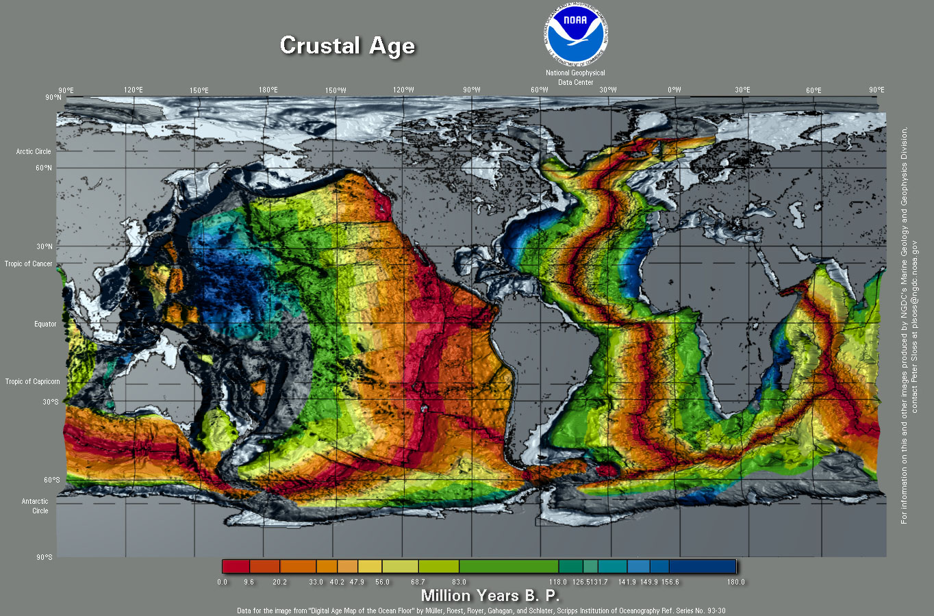
has allowed us to determine the age of the ocean floor over
virtually the entire Earth:
 |
(Click on this image
to see the entire Earth) |
This has also allowed us to map out probable spreading
patterns over time.
The net result is Divergent Boundaries.
- This creates a problem. We have already
seen that the Earth cannot be expanding. But Divergent
Boundaries CREATE new crust. This implies that
somewhere else, crust must be getting destroyed.
- Where? Hugo Benioff (in 1954, even before Vine
and Matthews published their work in 1963) got the evidence
from seismology.
Earthquake information:
 |
- Hugo Benioff, 1954 - discovered the
"Benioff Zone" -
- American (of Russian heritage)
seismologist.
- Invented seismological instruments
- Also invented electronic
musical instruments!
- Examined earthquakes near Kamchatka
Peninsula (Russia)
|
- Looked at earthquakes in Sea of Okhotsk and
Kamchatka Peninsula
- (We now call this a subduction zone)
- Middle: cross sections of this region along
transects from west to east.
- The data shows a downward dipping zone of
earthquakes (which is known as the "Benioff Zone").
- Further studies shows that the relative motion
indicates something pushing down from the east under the
western part.
- At the time (note that this was BEFORE the
work of Vine and Matthews), that's all anyone could say.
- But combined with the information from Vine
and Matthews showing Seafloor Spreading (Divergent Boundary),
it became clear that plates were coming together in a
Convergent Boundary.
These data from earthquakes (Convergent Boundary) and
paleomagnetism (Divergent Boundary)
allowed the discovery of what eventually became the Theory
of Plate Tectonics in the middle 1960's.
More links to web sites that contain information about Plate
Tectonics can be accessed through the Links Page of this
web site. The figures shown here were taken and/or
modified from the USGS Plate Tectonics web pages.